Seekonk
Utseende
| Seekonk | |||
|---|---|---|---|
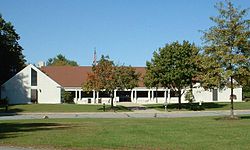
 Seekonk rådhus | |||
| Land | |||
| Delstat | |||
| Fylke | Bristol County | ||
| Status | town | ||
| Grunnlagt | 1636 (grunnlagt) 1812 (formelle rettigheter) | ||
| Postnummer | 02771 | ||
| Areal | 18,32 kvadratmile | ||
| Befolkning | 15 531[1] (2020) | ||
| Bef.tetthet | 847,76 innb./kvadratmile | ||
| Antall husholdninger | 5 958 | ||
| Høyde o.h. | 18[2] meter | ||
| Nettside | www | ||
 Seekonk 41°48′30″N 71°20′15″V | |||

Seekonk er en kommune (town) i Bristol County i delstaten Massachusetts i USA.[2] Ved folketellingen i 2000 bodde det 13 425 personer i byen. Den har ifølge United States Census Bureau et areal på totalt 47,7 km² hvorav 0,3 km² er vann.
Befolkningsutvikling
[rediger | rediger kilde]| Befolkningsutviklingen i Seekonk, Massachusetts 1850-2010 | ||||
|---|---|---|---|---|
| År | Innbyggere | |||
| 1850 | 2 243 | |||
| 1860 | 2 662 | |||
| 1870 | 1 021 | |||
| 1880 | 1 227 | |||
| 1890 | 1 317 | |||
| 1900 | 1 673 | |||
| 1910 | 2 397 | |||
| 1920 | 2 898 | |||
| 1930 | 4 762 | |||
| 1940 | 4 912 | |||
| 1950 | 6 104 | |||
| 1960 | 8 399 | |||
| 1970 | 11 116 | |||
| 1980 | 12 269 | |||
| 1990 | 13 046 | |||
| 2000 | 13 425 | |||
| 2010 | 13 722 | |||
Kilde: Tellinger og prognoser fra United States Census Bureau.[3][4][5][6][7][8][9][10][11][12] | ||||
Referanser
[rediger | rediger kilde]- ^ https://data.census.gov/cedsci/table?t=Populations%20and%20People&g=0100000US,%241600000&y=2020; folketellingen i USA 2020; redaktør: Bureau of the Census; besøksdato: 1. januar 2022.
- ^ a b «Seekonk». Geographic Names Information System, U.S. Geological Survey.
- ^ «Total Population (P1), 2010 Census Summary File 1». American FactFinder, All County Subdivisions within Massachusetts. United States Census Bureau. 2010.
- ^ «Massachusetts by Place and County Subdivision - GCT-T1. Population Estimates». United States Census Bureau. Arkivert fra originalen 12. februar 2020. Besøkt 12. juli 2011.
- ^ «1990 Census of Population, General Population Characteristics: Massachusetts» (PDF). US Census Bureau. desember 1990. Table 76: General Characteristics of Persons, Households, and Families: 1990. 1990 CP-1-23. Besøkt 12. juli 2011.
- ^ «1980 Census of the Population, Number of Inhabitants: Massachusetts» (PDF). US Census Bureau. desember 1981. Table 4. Populations of County Subdivisions: 1960 to 1980. PC80-1-A23. Besøkt 12. juli 2011.
- ^ «1950 Census of Population» (PDF). Bureau of the Census. 1952. Section 6, Pages 21-10 and 21-11, Massachusetts Table 6. Population of Counties by Minor Civil Divisions: 1930 to 1950. Besøkt 12. juli 2011.
- ^ «1920 Census of Population» (PDF). Bureau of the Census. Number of Inhabitants, by Counties and Minor Civil Divisions. Pages 21-5 through 21-7. Massachusetts Table 2. Population of Counties by Minor Civil Divisions: 1920, 1910, and 1920. Besøkt 12. juli 2011.
- ^ «1890 Census of the Population» (PDF). Department of the Interior, Census Office. Pages 179 through 182. Massachusetts Table 5. Population of States and Territories by Minor Civil Divisions: 1880 and 1890. Besøkt 12. juli 2011.
- ^ «1870 Census of the Population» (PDF). Department of the Interior, Census Office. 1872. Pages 217 through 220. Table IX. Population of Minor Civil Divisions, &c. Massachusetts. Besøkt 12. juli 2011.
- ^ «1860 Census» (PDF). Department of the Interior, Census Office. 1864. Pages 220 through 226. State of Massachusetts Table No. 3. Populations of Cities, Towns, &c. Besøkt 12. juli 2011.
- ^ «1850 Census» (PDF). Department of the Interior, Census Office. 1854. Pages 338 through 393. Populations of Cities, Towns, &c. Besøkt 12. juli 2011.
Eksterne lenker
[rediger | rediger kilde]- (en) Offisielt nettsted
- (en) Seekonk, Massachusetts – kategori av bilder, video eller lyd på Commons


