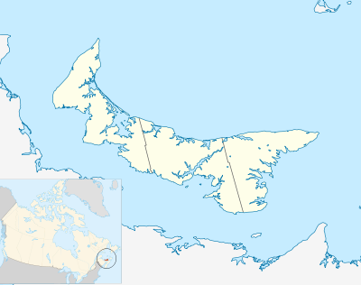
Modul:Kartposisjon/data/Prince Edward Island
Utseende

| ||||
| navn | Prince Edward Island | |||
|---|---|---|---|---|
| ISO 3166-region | CA-PE | |||
| ytterpunktenes koordinatverdier | ||||
| 47.3 | ||||
| -64.9 | ←↕→ | -61.6 | ||
| 45.5 | ||||
| kartets sentrum | 46°24′N 63°15′V | |||
| standardbredde | 240px (standard) | |||
| bilde | Canada Prince Edward Island location map 2.svg | |||
Modul:Kartposisjon/data/Prince Edward Island er en posisjonskartdefinisjon brukt for å legge markører og merker på et projeksjonskart over Prince Edward Island. Markørene plasseres ved hjelp av angitte bredde- og lengdegrader på et angitt standardkart, et angitt relieff-kart eller et angitt alternativt kartbilde.
Bruk
[rediger kilde]Disse definisjonene brukes av følgende maler ved påkalling med parameteren «Prince Edward Island»:
{{Kartposisjon | Prince Edward Island | ...}}{{Kartposisjon mange | Prince Edward Island | ...}}{{Kartposisjon+ | Prince Edward Island | ...}}{{Kartposisjon~ | Prince Edward Island | ...}}
Kartdefinisjon
[rediger kilde]navn = Prince Edward Island- Navnet som brukes som tekst på standardkartet
bilde = Canada Prince Edward Island location map 2.svg- Standard kartbilde, uten «Fil:»
topp = 47.3- Breddegraden i toppen av kartet, i desimalgrader
bunn = 45.5- Breddegrad i bunn av kartet, i desimalgrader
venstre = -64.9- Lengdegrad i venstre kant av kartet, i desimalgrader
høyre = -61.6- Lengdegrad i høyre kant av kartet, i desimalgrader
Presisjon
Lengdegrad: fra vest mot øst dekker dette kartet 3 grader.
- Ved en bildebredde på 200 piksler, tilsvarer dette 0.015 grader per piksel.
- Ved en bildebrede på 1 000 piksler, tilsvarer dette 0.003 grader per piksel.
Breddegrad: fra nord til sør dekker dette kartet 1.8 grader.
- Ved en bildebredde på 200 piksler, tilsvarer dette 0.009 grader per piksel.
- Ved en bildebredde på 1 000 piksler, tilsvarer dette 0.0018 grader per piksel.
Se også
[rediger kilde]- Kartposisjonsmaler
- Mal:Kartposisjon, for å vise et merke med tekst ved hjelp av lengdegrad og breddegrad
- Mal:Kartposisjon mange, for å vise opp til ni markører og tekster
- Mal:Kartposisjon+, for å vise et ubegrenset antall merker og tekster
