
Fil:Theoretical Search Area MH370.svg

Størrelse for denne PNG-forhåndsvisningen av denne SVG-filen: 800 × 475 piksler Andre oppløsninger: 320 × 190 piksler | 640 × 380 piksler | 1 024 × 609 piksler | 1 280 × 761 piksler | 2 560 × 1 521 piksler | 1 156 × 687 piksler.
Opprinnelig fil (SVG-fil, standardstørrelse 1 156 × 687 piksler, filstørrelse: 531 KB)
| Denne filen er fra Wikimedia Commons og kan brukes av andre prosjekter. Informasjonen fra filbeskrivelsessiden vises nedenfor. |
Beskrivelse
| Beskrivelse |
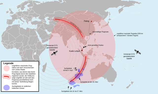
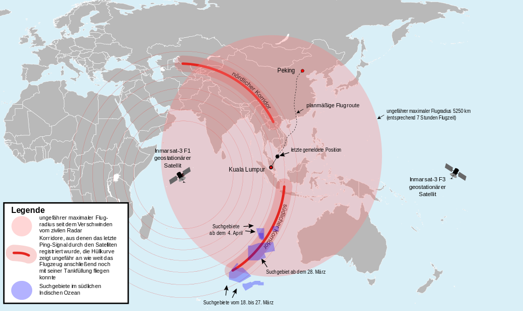
English: Map of the area where Malaysia Airlines Flight 370 could be found theoretically (svg version) (German).
Deutsch: Karte des Gebietes in dem sich der Malaysia-Airlines-Flug 370 theoretisch befinden könnte (svg-Version) (Deutsch).
中文(简体):马来西亚航空370号班机可能出现的区域 (德文)
中文(繁體):馬來西亞航空370號班機可能出現的區域 (德文) |
| Dato | (UTC) |
| Kilde |
This file was derived from: Theoretical Search Area MH 370.png: |
| Opphavsperson |
Vektor: |
| SVG utvikling |
Lisensiering
Jeg, rettighetsinnehaver av dette arbeidet, publiserer det herved under følgende lisens:
Denne filen er lisensiert under lisensen Creative Commons Navngivelse-DelPåSammeVilkår 2.0 Generisk
- Du står fritt:
- til å dele – til å kopiere, distribuere og overføre verket
- til å blande – til å endre verket
- Under de følgende betingelsene:
- navngivelse – Du må kreditere verket på passende vis, lenke til lisensen og indikere hvorvidt det har blitt gjort endringer. Du kan gjøre det på enhver rimelig måte, men ikke på en måte som antyder at lisensgiveren støtter deg eller din bruk av verket.
- del på samme vilkår – Dersom du remikser, omarbeider eller på annen måte bygger på dette verket, må du kun distribuere resultatet under den samme eller en samsvarende lisens som denne.
Orginal opplastningslogg
This image is a derivative work of the following images:
- _ licensed with Cc-by-sa-2.0
- 2014-03-16T21:45:55Z Furfur 1881x1159 (249004 Bytes) Korridor enger gemacht, Satellitenname ergänzt
- 2014-03-15T19:23:15Z Furfur 1879x1160 (247882 Bytes) Grafik geändert nach Informationen von http://www.news.com.au/national/uighur-separatists-claim-over-missing-flight-mh370-may-be-reexamined/story-fncynjr2-1226855911080
- 2014-03-15T09:19:20Z Pechristener 2509x1548 (153746 Bytes) Kreis grösser mit einem Radius von 4800 km (gemäss Disk bei Kartenwerkstatt)
- 2014-03-15T08:17:57Z Pechristener 2509x1548 (152252 Bytes) {{Information |Description={{en|1=Map of the area, where [[:en: Malaysia Airlines Flight 370|Malaysia Airlines Flight 370]] could be found theoretically.}} {{de|1=Karte des Gebietes in dem sich der [[:de: Malaysia-Airlines-Fl
Uploaded with derivativeFX
Filhistorikk
Klikk på et tidspunkt for å vise filen slik den var på det tidspunktet.
| Dato/klokkeslett | Miniatyrbilde | Dimensjoner | Bruker | Kommentar | |
|---|---|---|---|---|---|
| nåværende | 22. apr. 2016 kl. 16:46 | | 1 156 × 687 (531 KB) | Perhelion | typo (per hint on talkpage) |
| 19. apr. 2015 kl. 23:14 |  | 1 156 × 687 (534 KB) | Perhelion | m | |
| 19. apr. 2015 kl. 23:08 |  | 1 156 × 687 (535 KB) | Perhelion | fix font, cleaned | |
| 5. apr. 2014 kl. 16:00 |  | 1 156 × 687 (1,46 MB) | Furfur | update according to http://www.bbc.com/news/world-asia-26514556 | |
| 28. mar. 2014 kl. 11:42 |  | 1 102 × 688 (1,45 MB) | Furfur | Bildkosmetik | |
| 28. mar. 2014 kl. 11:33 |  | 1 110 × 688 (1,45 MB) | Furfur | search areas specified, + new search area (source: Australian Maritime Safety Authority (Amsa) ) | |
| 23. mar. 2014 kl. 21:12 |  | 1 146 × 680 (1,57 MB) | Pechristener | touchup: one '-' missing in 'Inmarsat-3' / drawing frame to avoid that label of flight radius kicks the ride border | |
| 23. mar. 2014 kl. 19:07 |  | 1 063 × 672 (1,4 MB) | Furfur | enlarged the possible flight radius (compare http://www.bbc.com/news/world-asia-26705073), modified image legend, extended southern arc | |
| 23. mar. 2014 kl. 12:04 |  | 1 068 × 699 (1,51 MB) | Pechristener | typo corrected / consequent capital & minuscule writing of the labels | |
| 23. mar. 2014 kl. 11:57 |  | 1 068 × 699 (1,51 MB) | Pechristener | slight touchup: not bent or diagonal labels giving better rendering results / usual flight path instead of direct connetion (source: Flightradar24) / layers reorderd to have the satelite icon on the top / current search area added as indicated on graph... |
Filbruk
Den følgende siden bruker denne filen:
Global filbruk
Følgende andre wikier bruker denne filen:
- Bruk i de.wikipedia.org
- Bruk i gl.wikipedia.org
- Bruk i sh.wikipedia.org
- Bruk i ug.wikipedia.org
- Bruk i uk.wikipedia.org