
Fil:Map of Indiana highlighting Union County.svg

Størrelse for denne PNG-forhåndsvisningen av denne SVG-filen: 391 × 599 piksler Andre oppløsninger: 156 × 240 piksler | 313 × 480 piksler | 501 × 768 piksler | 668 × 1 024 piksler | 1 337 × 2 048 piksler | 722 × 1 106 piksler.
Opprinnelig fil (SVG-fil, standardstørrelse 722 × 1 106 piksler, filstørrelse: 42 KB)
| Denne filen er fra Wikimedia Commons og kan brukes av andre prosjekter. Informasjonen fra filbeskrivelsessiden vises nedenfor. |
Beskrivelse
| Beskrivelse |
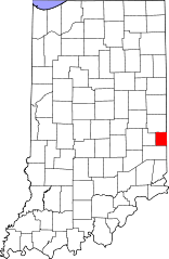
English: This is a locator map showing Union County in Indiana. For more information, see Commons:United States county locator maps. |
| Dato | |
| Kilde |
Eget verk: English: The maps use data from nationalatlas.gov, specifically countyp020.tar.gz on the Raw Data Download page. The maps also use state outline data from statesp020.tar.gz. The Florida maps use hydrogm020.tar.gz to display Lake Okeechobee. |
| Opphavsperson | David Benbennick |
Lisensiering
| Jeg, opphavsrettensholderen til dette verket, frigir dette verket til allmennheten. Dette gjelder på verdensbasis. I enkelte land kan dette være juridisk umulig. I så fall: Jeg gir hvem som helst retten til å bruke dette verket for ethvert formål, uten noen vilkår, med mindre slike vilkår kreves ved lov. |
Filhistorikk
Klikk på et tidspunkt for å vise filen slik den var på det tidspunktet.
| Dato/klokkeslett | Miniatyrbilde | Dimensjoner | Bruker | Kommentar | |
|---|---|---|---|---|---|
| nåværende | 25. jun. 2024 kl. 16:50 | | 722 × 1 106 (42 KB) | Nux | uniform colors with good contrast |
| 19. jun. 2024 kl. 22:42 |  | 722 × 1 106 (42 KB) | Nux | fix rendering (remove clipping) | |
| 12. feb. 2006 kl. 14:12 |  | 2 887 × 4 423 (56 KB) | David Benbennick | {{subst:User:Dbenbenn/clm|county=Union County|state=Indiana}} |
Filbruk
Den følgende siden bruker denne filen:
Global filbruk
Følgende andre wikier bruker denne filen:
- Bruk i ar.wikipedia.org
- Bruk i bg.wikipedia.org
- Bruk i bpy.wikipedia.org
- Bruk i cdo.wikipedia.org
- Bruk i ceb.wikipedia.org
- Bruk i ce.wikipedia.org
- Bruk i cy.wikipedia.org
- Bruk i de.wikipedia.org
- Bruk i en.wikipedia.org
- List of counties in Indiana
- Union County, Indiana
- Liberty, Indiana
- West College Corner, Indiana
- Template:Union County, Indiana
- Brownsville Township, Union County, Indiana
- Center Township, Union County, Indiana
- Harmony Township, Union County, Indiana
- Harrison Township, Union County, Indiana
- Liberty Township, Union County, Indiana
- Union Township, Union County, Indiana
- Brownsville, Indiana
- Dunlapsville, Indiana
- User:Nyttend/County templates/IN/2
- National Register of Historic Places listings in Union County, Indiana
- Category:Populated places in Union County, Indiana
- List of Indiana state historical markers in Union County
- Template:UnionCountyIN-geo-stub
- User:Br.gamache/sandbox
- Billingsville, Indiana
- Charlottesville, Union County, Indiana
- Clifton, Indiana
- Cottage Grove, Indiana
- Five Points, Union County, Indiana
- Lotus, Indiana
- Philomath, Indiana
- Roseburg, Union County, Indiana
- Salem, Union County, Indiana
- Witts Station, Indiana
- Yankee Town, Indiana
- Goodwins Corner, Indiana
- Kitchel, Indiana
- Quakertown, Indiana
- Hopeville, Indiana
- Bruk i eo.wikipedia.org
- Bruk i es.wikipedia.org
- Bruk i et.wikipedia.org
- Bruk i eu.wikipedia.org
- Bruk i fa.wikipedia.org
- Bruk i fr.wikipedia.org
- Bruk i hi.wikipedia.org
Vis mer global bruk av denne filen.