
Fil:LuxembourgPartitionsMap english.jpg
Ingen høyere oppløsning tilgjengelig.
LuxembourgPartitionsMap_english.jpg (433 × 569 piksler, filstørrelse: 46 KB, MIME-type: image/jpeg)
| Denne filen er fra Wikimedia Commons og kan brukes av andre prosjekter. Informasjonen fra filbeskrivelsessiden vises nedenfor. |

|
Denne filen er nå foreldet og erstattet av File:LuxembourgPartitionsMap english.png. Vær vennlig og bruk den andre filen. NB: Denne filen vil ikke bli slettet med mindre den uttrykkelig blir nominert til sletting.
|

|
Beskrivelse
| Beskrivelse |
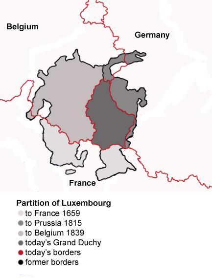
English: Map showing the partition of Luxembourg through the centuries.
Français : Carte montrant la partition du Luxembourg à travers les siècles, avec explications an anglais. |
| Dato | |
| Kilde |
|
| Opphavsperson | Spanish_Inquisition |
| Andre versjoner |
|


Lisensiering
| Jeg, opphavsrettensholderen til dette verket, frigir dette verket til allmennheten. Dette gjelder på verdensbasis. I enkelte land kan dette være juridisk umulig. I så fall: Jeg gir hvem som helst retten til å bruke dette verket for ethvert formål, uten noen vilkår, med mindre slike vilkår kreves ved lov. |
Filhistorikk
Klikk på et tidspunkt for å vise filen slik den var på det tidspunktet.
| Dato/klokkeslett | Miniatyrbilde | Dimensjoner | Bruker | Kommentar | |
|---|---|---|---|---|---|
| nåværende | 21. jul. 2008 kl. 19:11 | | 433 × 569 (46 KB) | Pretty Green~commonswiki | {{Information |Description= As previous, with rivers removed from map for clarity |Source= previous version |Date= 21 July 2008 |Author= Spanish Inquisition, modified by Pretty Green |Permission= |other_versions= }} |
| 3. sep. 2006 kl. 15:58 |  | 433 × 569 (82 KB) | Spanish Inquisition | Map showing the partition of Luxembourg thorugh the centuries with english expanantions. Modification of the image LuxembourgPartitionsMap.png by user:QuartierLatin1968 14:10, 22 Apr 2005 (UTC). Author: user:Spanish_Inquisition Date: 3rd September 2006 |
Filbruk
Den følgende siden bruker denne filen:
Global filbruk
Følgende andre wikier bruker denne filen:
- Bruk i bg.wikipedia.org
- Bruk i en.wikipedia.org
- Bruk i he.wikipedia.org
- Bruk i it.wikipedia.org
- Bruk i mn.wikipedia.org
- Bruk i th.wikipedia.org
- Bruk i vi.wikipedia.org