
Fil:London1300-marking the spot of the future Marshalsea.png

London1300-marking_the_spot_of_the_future_Marshalsea.png (700 × 536 piksler, filstørrelse: 693 KB, MIME-type: image/png)
| Denne filen er fra Wikimedia Commons og kan brukes av andre prosjekter. Informasjonen fra filbeskrivelsessiden vises nedenfor. |
Beskrivelse
| Beskrivelse |
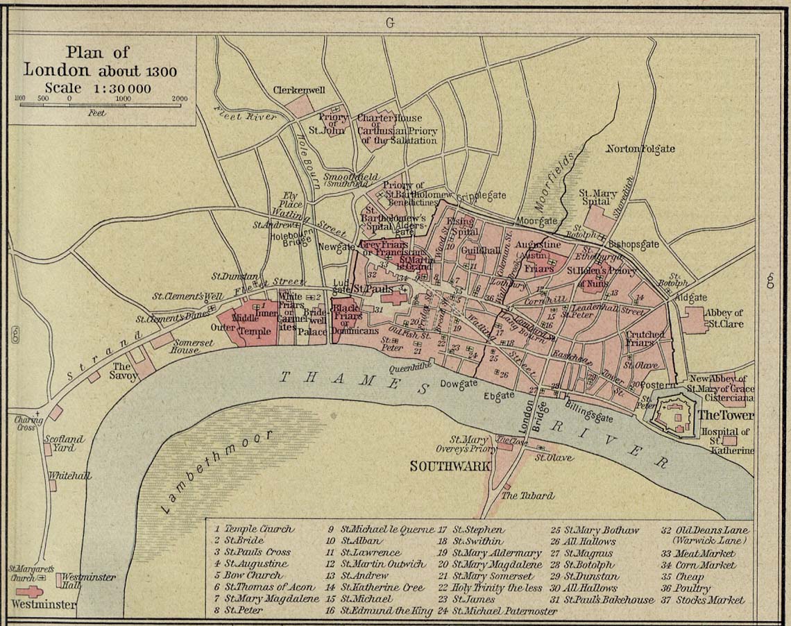
English: Source: Commons Image:London 1300 Historical Atlas William R Shepherd (died 1934).PNG
Description: A map of London in 1300 from a historical atlas by William R Shepherd. Apart from religious foundations and two or three other complexes, the city is confined within its walls, the bulk and heart of the City of London today. The City is flanked to the east and west by the royal fortress of the Tower of London and the royal palace of en:Bridewell. The route from the city to the royal centre of Westminster is not yet fully built up. There is a settlement at en:Southwark, but it is very small. The approximate location of the future Marshalsea prison (first mentioned 1370) is marked in blue. |
| Dato | |
| Kilde | Shepherd, William R. Historical Atlas. New York, Henry Holt and Company, 1923. Direct JPG, Indirect HTML |
| Opphavsperson | Shepherd, William R. (d. 1934) |
| Tillatelse (Gjenbruk av denne filen) |
This image is in the public domain due to its age. |
.PNG)
Lisensiering
|
Dette verket er offentlig eiendom i Norge, EU og land der den opphavsrettslige vernetiden etter opphavsmannens død er 70 år eller kortere. Merk at noen land har lengre vernetid.
| |
| Denne filen har blitt identifisert til å være fri for kjente restriksjoner under lov om opphavsrett, inkludert alle relaterte og nærstående rettigheter. | |
Orginal opplastningslogg
- 2007-12-23 05:07 SlimVirgin 700×536×8 (709283 bytes) {{PD-old}} Source: Commons [[:Image:London 1300 Historical Atlas William R Shepherd (died 1934).PNG]] Description: A map of London in 1300 from a historical atlas by William R Shepherd. Apart from religious foundations and two or three other complexes,
Filhistorikk
Klikk på et tidspunkt for å vise filen slik den var på det tidspunktet.
| Dato/klokkeslett | Miniatyrbilde | Dimensjoner | Bruker | Kommentar | |
|---|---|---|---|---|---|
| nåværende | 7. jun. 2008 kl. 04:24 | | 700 × 536 (693 KB) | File Upload Bot (Magnus Manske) | {{BotMoveToCommons|en.wikipedia}} {{Information |Description={{en|Source: Commons en::Image:London 1300 Historical Atlas William R Shepherd (died 1934).PNG Description: A map of London in 1300 from a historical atlas by William R Shepherd. Apart fr |
.PNG)
Filbruk
Den følgende siden bruker denne filen:
Global filbruk
Følgende andre wikier bruker denne filen:
- Bruk i es.wikipedia.org
- Bruk i it.wikipedia.org